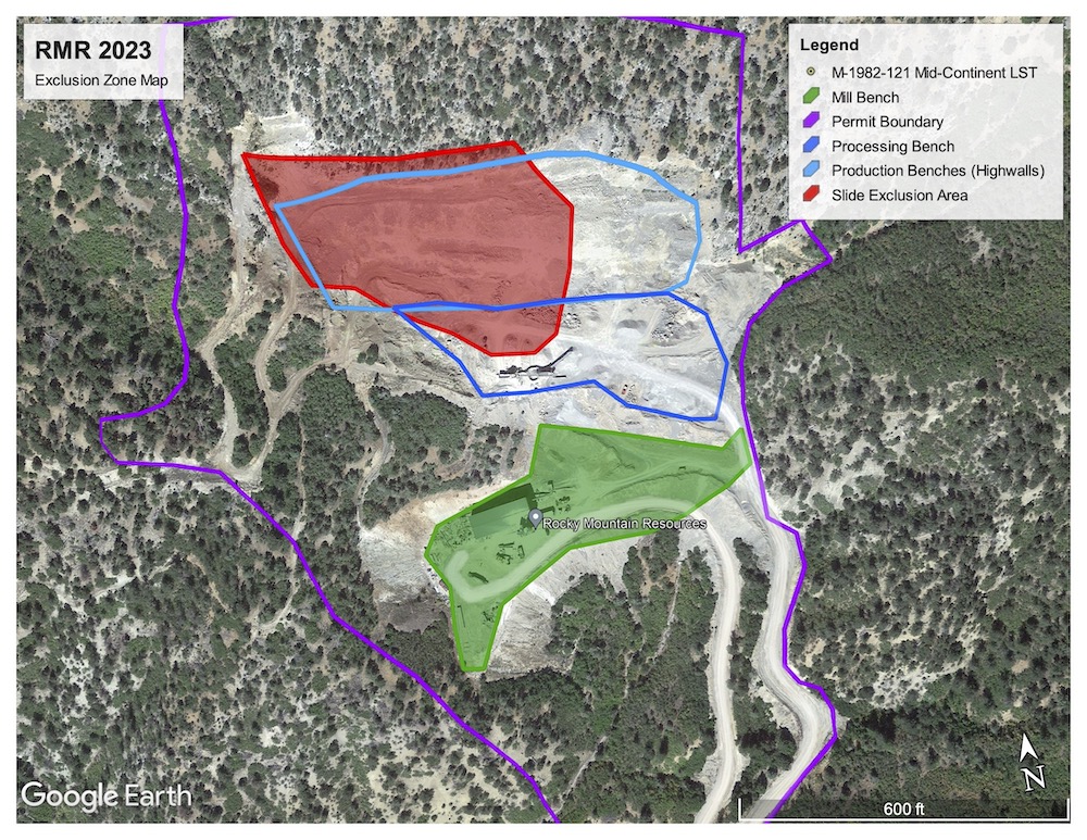
The Colorado Division of Reclamation, Mining and Safety has regulated operations at the limestone quarry since it was first opened by Mid-Continent Resources in 1982. The quarry continues to be recognized by the state agency as the “Mid-Continent Quarry.”
The agency requires quarterly reports from the mining company, conducts inspections at the mine site at least once per year, and holds a reclamation bond. These bonds protect taxpayers from bearing the costs of mine site cleanup if the mine owner fails to complete the work.
In state regulatory matters, Rocky Mountain Industrials uses a related corporate name, RMR Aggregates Inc.
Here is a timeline of the state regulatory process. Selected documents are provided for reference.
2023 Rockslide: Citation and Stipulated Agreement
Jan. 18, 2023: The western half of the quarry’s highwall broke loose in the mid-afternoon, bringing tons of limestone slabs, boulders and rubble down into the working area of the quarry. No one was in the path of the slide. State and federal officials responded within days.
Jan. 23, 2023: DRMS mine inspectors Amy Yeldell and Dustin Czapla visited the quarry and produced a detailed inspection report describing the slide.
Jan. 25, 2023: DRMS issued a notice of “Possible Violation” alleging that RMI’s mining methods “resulted in destabilized highwalls” and that the company “failed to control erosion and sedimentation on the affected lands.”
The notice required RMI to appear before the Colorado Mined Land Reclamation Board for a formal hearing. (The board is an appointed panel that considers permit violations and imposes penalties and remedies.)
April 19, 2023: DRMS staff negotiated a Stipulated Agreement with RMI in lieu of the formal hearing. Under the agreement:
- RMI acknowledged “awareness” of its failure to protect areas outside its permit boundary from slides or damage.
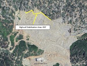
- RMI was ordered to seek a Technical Revision to its permit to establish a long-term geologic monitoring and stability plan. The application must include a geotechnical stability plan prepared by an accredited engineering firm.
- DRMS imposed a cease-and-desist order for any mining on the production bench until a technical revision to RMI’s mining permit is approved by DRMS.
A Technical Revision (TR) is handled directly between DRMS staff and the mine operator. Public comment is not a part of this process, and Colorado Mined Land Reclamation Board (MLRB) action is not needed to finalize the TR. Technical Revisions are numbered for each mine. Revisions in this process spanned from TR 6 to TR 9.
Technical Revisions 6 and 7, October 2023 to December 2024
Aug. 31, 2023: RMI submitted its geotechnical stability plan, entitled “Rock Failure Analysis and Stability Report,” prepared by Kilduff Underground Engineering Inc., of Denver as TR 6. (Learn about the Kilduff report here.)
Sept. 29, 2023: DRMS responded with an extensive review and critique. Further back-and-forth continued between DRMS and Kilduff, with documents issued Nov. 29, 2023, Feb. 8, 2024, and March 29, 2024.
March 29, 2024: Kilduff submitted a revised and more detailed version of the “Rock Failure Analysis and Stability Report.”
April 1, 2024: DRMS accepted the final Kilduff geotechnical plan and approved TR 6.
 May 28, 2024: DRMS conducted an on-site inspection, and again found problems with the mine operation and permit compliance. The agency called for a mine plan, TR 7, that would describe a safety berm to protect workers from further rockfall.
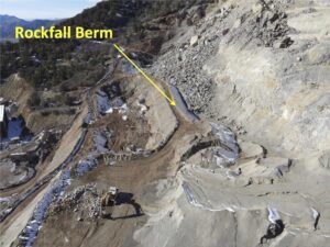
July 2024: RMI submitted a proposal to create a 600-foot-long rockfall berm. DRMS raised clarifying questions, RMI revised its proposal and DRMS approved the plan.
Dec. 16, 2024: RMI completed work on the berm, which was accepted by DRMS, completing TR 7.
Reclamation bond increase
and Technical Revisions 8 and 9, August 2024 to March 2027
From 2019 until 2024, DRMS held a reclamation bond for the RMI quarry of $336,179.
Aug. 27, 2024: DRMS began a “surety increase” (SI) process to increase the bond to (1) account for inflation and (2) cover new costs for slope stabilization work. DRMS gave RMI two months to obtain price quotes for rock bolting the overhanging cliff. DRMS stated that rock bolting is the only slope stabilization option that does not extend beyond the quarry’s approved state and federal boundaries.
Oct. 25, 2024: RMI challenged the state’s rationale for including rock bolting in the new reclamation bond.
Nov. 15, 2024: DRMS split the process in two, continuing with the SI to increase the reclamation bond while initiating TR 8 to create a narrative description of the rock bolting project. DRMS raised the reclamation bond by 33 percent, to $489,758, for standard reclamation work such as demolishing structures, reshaping mined benches, ripping out access roads, spreading stockpiled topsoil and revegetating the site. It also extended the deadline for rock bolting price quotes.
Of note: Active mining operations ceased at the quarry in December 2024, some milling and loading equipment was dismantled and removed from the site in January 2025, and the U.S. Department of Interior issued a decision in January 2025 barring the company from further mining until a new federal permit and sales contract were instated.
Jan. 29, 2025: For its TR 8 submittal, RMI filled out a standard form and submitted confidential supporting documents that proposed increasing the quarry permit area from 38 acres to 56 acres.
Feb. 5, 2025: In response to this alarming request, the Citizens’ Alliance sent a pointed letter to DRMS calling for denial of the TR 8 acreage expansion proposal.
Feb. 7, 2025: DRMS issued a sharp letter of denial of RMI’s TR 8, noting that acreage increases can only be handled in a Permit Amendment process, which requires public review and MLRB oversight. DRMS noted that it would not consider a permit amendment proposal unless RMI obtained an approved plan of operations from BLM, which it did not have.
April 11, 2025: After several extensions, RMI submitted a TR 9 proposal to describe the rock bolting project.
April 28, 2025: Following extensive review, DRMS asked for numerous revisions.
July 9, 2025: RMI submitted a second TR 9. A week later, DRMS again asked for revisions.
 Oct. 3, 2025: RMI submitted a third TR 9, with extensive redactions to the version provided to the public. DRMS staff checked this version against its April critique and found the this submittal to be adequate.
Oct. 28, 2025: DRMS sent RMI a new reclamation bond surety increase with a 33-page pricing schedule for standard site reclamation and rock bolting. The bond was proposed at $1,315,949.
Nov. 5, 2025: DRMS approved RMI’s TR 9 narrative describing rock bolting work.
Nov. 26, 2025: RMI disputed some costs included in the proposed bond.
Dec. 17, 2025: DRMS responded to RMI’s disputes over costs, explaining its rationale.
Jan. 12, 2026: DRMS re-issued the reclamation bond surety increase letter and schedule, adjusting the total bond downward to $1,194,329.
March 18, 2026: The Colorado Mined Land Reclamation Board approved a Stipulated Agreement with RMI confirming the bond amount at $1,194,329 and allowing RMI to pay the $704,571 increase in five installments over the following year. Payments are due on May 1, Sept. 1 and Nov. 1, 2026 and on Jan. 5 and March 1, 2027.