The New 2026 Mine Expansion Proposal
The limestone quarry is mothballed, but Rocky Mountain Industrials continues to seek a new mining permit.
On May 29, 2026, the company submitted a Modified Plan of Operations to the U.S. Bureau of Land Management (BLM). On June 26, 2026, BLM Colorado River Valley Field Manager Lisa Dawson announced that the submitted plan is complete.
Two previous submissions, made in January and December 2025, were found to be incomplete and sent back to Rocky Mountain Industrials for revisions.
The plan document has not been released to the public. BLM’s Lisa Dawson said it contains these elements:
- An expansion of the permit boundary from the current 16 acres to 56.10 acres.
- A request for a mineral materials sales contract.
- Plans to address longstanding permit violation issues.
The plan does NOT address the 2018 plan for a massive mine expansion to a 447-acre permit area. That plan has not been withdrawn.
Trump administration pressure to approve the permit
In June 2026, knowing a new mining plan submission was imminent, the City of Glenwood Springs and the Citizens’ Alliance sent a delegation to Washington, D.C. to lobby for the community’s interests.
Glenwood Springs Mayor Pro-tem Erin Zalinski, City Manager Steve Boyd and City Attorney Karl Hanlon met with the newly-confirmed director of U.S. Bureau of Land Management (BLM), Stevan Pearce, and other top BLM officials.
Zalinski later recounted what Pearce said. “He let us know this approval was to be viewed favorably under direction of the White House. We were encouraged to come back to him with bullet points for what we would be willing to accept.”
“These aggressive statements prompted by high-level pressure from the White House raise serious concerns right now,” said Michael Gamba, a Citizens’ Alliance board member and former Glenwood Springs mayor who participated in the Washington, D.C., lobbying trip.
What this submitted plan could mean
Expansion of the permit boundary
Some of the 56 acres would resolve the longstanding violation that the quarry’s milling bench, access road and stormwater structures are outside the federal permit boundary.
For comparison, the state mining permit area is 38 acres, and takes in the milling bench and access road.
> The key point: Expansion is aimed at the area upslope of the existing quarry. It would allow the company to mine hundreds of feet upslope, blasting out the unstable cliff that remains from the 2023 slope collapse and upward to a point where the unstable limestone layers pinch out.
Request for a mineral materials sales contract
This would enable RMI to mine limestone and sell it for common variety purposes, such as road base, aggregate, decorative boulders, methane reduction in coal mines and chicken grit.
Under a sales contract, RMI would have to pay a fee to the federal government for taking common variety limestone from public lands.
Plans to address longstanding permit violation issues
BLM cited Rocky Mountain Industrials for these violations in 2022. To date, RMI has not remedied them.
- Mining facilities outside federal permit boundary.
- Stormwater structures built without permission and outside permit boundary.
- Inadequate stockpile of topsoil for reclamation.
- Improper benching of the quarry’s highwall.
Next steps
BLM staff will conduct a technical review of the submitted Modified Plan of Operations.
The Citizens’ Alliance expects to learn more about what is entailed in a technical review in the coming weeks. Watch this page or sign up here for email updates.
Once the technical review is complete, BLM will release the Modified Plan of Operations document and begin a public review process.
This will include opportunities for YOU to make your voice heard as BLM weighs the value the mine expansion proposal against the severe impacts it poses to the Glenwood Springs community.
Stay informed. Sign up here to endorse the cause and receive email updates.
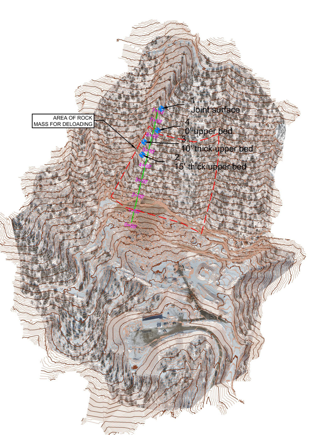
A contour map of the limestone quarry area. Dark areas near the bottom of the image show the location of the metal building on the milling bench. The map extends upslope and northward onto the vegetated mountainside above the quarry.
The black line indicates an “area of rock mass for deloading.” This line is likely to indicate the proposed expansion area of the limestone mine.
The lower edge of the area is along the top of the west highwall and overhanging cliff, where the unstable limestone layer is about 15 feet thick.
The area extends upslope 200 to 300 vertical feet. Over this section, the upper limestone layer decreases in thickness from 15 feet to 10 feet. Above the outlined area, the upper limestone layer pinches out entirely.
Contour map prepared by Kilduff Underground Engineering Inc., author of “Rock Failure Analysis and Stability,” the 2023 geotechnical report prepared for Rocky Mountain Industrials following the Jan. 18, 2023, slope collapse.
Resources
BLM Completeness Review letter to Rocky Mountain Industrials, with 17 points for improvements to the Plan of Operations, Feb. 28, 2025
BLM letter to Rocky Mountain Industrials determining that the May 29, 2026, Plan of Operations is complete, and listing next steps, June 25, 2026
News coverage
Glenwood Springs Post Independent, July 6, 2026
Hickenlooper, Glenwood officials speak out against proposed RMI Quarry expansion
Glenwood Springs Post Independent, July 2, 2026
BLM advances review of RMI quarry plan above Glenwood Springs

A view of the mothballed limestone quarry from the saddle parking area on Transfer Trail. The unstable layers of limestone that remain after the 2023 slope collapse are visible at the top of the mined area.
Photo by Ginny Minch.